Reports
Project Midan: New Information from the Archive
by David Albright, Sarah Burkhard, and Frank Pabian
March 5, 2020
Iran’s Project Midan, part of Project 110 of the Amad Plan, was responsible for building an underground nuclear weapon test site in the early 2000s. Based on documents in the Iran Nuclear Archive, Iran had picked five possible locations in remote areas of Iran, an effort described in an earlier Institute study (see Figure 1). 1 The Institute’s last report on Project Midan left unanswered whether Iran had made a decision about which of five sites it would develop as an underground nuclear weapons test site. Newly acquired documents from the archive possibly suggest that the Lut Desert sites were emerging as more likely choices.
The documents include excerpts from a geological and hydrological survey in the Lut desert. Although it is unclear if the scientists were from the Amad Plan, Project Midan considered the report and its findings important and relevant enough to collect and keep the survey in the archive. According to senior Israeli intelligence officials who have been examining and assessing the archive since early 2018, in all of the documentation reviewed so far relevant to Project Midan, there is a record of only this one collected ground survey near any of the five possible test locations. The singularity of this ground survey raises the question of whether Project Midan was focusing its search on the Lut desert, and specifically one of the three selected potential test sites in the desert or possibly another nearby location.
This report presents the information Project Midan collected from the ground survey, supplemented by our analysis and verification of it.
Ground Survey
The new documentation concerns an expedition conducting a detailed geological and hydrological survey in a remote area northeast of the town Nayband, located in the Khorasan province in the Lut desert about 230 kilometers to the north of Kerman. The available documentation from the archive includes several pages of a report on the expedition itself and several ground photos, including some prominent cultural locations, taken by team members as they travelled to the main area of the ground survey. Figure 2 shows a test site survey excursion map, developed by Israeli government experts, with the route of the expedition overlain on a Google Earth image of the area, showing the route in relation to the three previously identified nuclear test sites in the Lut desert, where test site one is roughly 200 kilometers (air-line) from the route, test site two 90 kilometers, and test site three 70 kilometers. According to the expedition map, the team traveled north from Kerman, along Highway 91, to Nayband. Four locations are marked with a number on the map, possibly representing planned stops. Based on ground photos associated with the survey, after reaching Nayband, the team appears to have gone off-roading into the desert. Figure 3 is an illustrative photo of Nayband that was not part of the archive report.
Figure 4 is an excerpt from the report, along with an English translation. The excerpt focuses on the expedition’s reporting of seven wells of varying depths along and alongside a fault, including their ground water levels. Coordinates in the expedition’s report identify the seven wells, allowing the Institute to geo-locate them with commercially available satellite imagery to corroborate information from the report. High resolution imagery from Apple Maps confirms the existence of seven wells at the given coordinates, which align perfectly along what appears to be a geologic fault trending northwest/southeast. As reported in the translated text in Figure 4, the wells are located in the desert about 50 kilometers northeast of Nayband. The expedition’s report lists the water depth in each of the wells (three with water at the surface) and their mineral characteristics. Figure 5 is an undated Apple Maps image providing an overview of the seven wells. Figures 6-12 show the individual wells, where Figure 8 correlates the satellite image with a ground photo from the survey. A small shaft could be identified for wells 1, 4, and 7.
According to Israeli intelligence officials, and supported by our own satellite imagery analysis, some kind of mining and ore processing effort also occurred within the fault zone in the past. According to Israeli officials, this ore processing effort was established in about 2003 and was subsequently abandoned after 2004. Available satellite imagery supports the conclusion that the entire effort has been abandoned for quite some time. Figure 13 shows the area of the possible abandoned mining activity near well 5. Based on the satellite imagery and the data included in the expedition report, this survey may have predated this mining effort and in fact may have had the purpose of analyzing the prospects of establishing a mine to extract exploitable ore in that area. According to the survey, the ore may contain copper.
Additional ground photos from the survey report were correlated with commercial satellite imagery, leading to the identification of several sites along the route. Among the sites that could be identified from the ground photos include the town of Nayband (shown in a distant view, Figure 14), a colonial fort with crenellated walls and towers along Highway 91 that is located near Nayband (Figures 15 and 16), and a communications tower (labeled ”pole”), which has subsequently undergone improvements. The tower and support structures are situated on the top of a small butte that is located about six kilometers southwest of the well area (see Figures 17 - 19).
Findings and Recommendations
According to Israeli intelligence officials, the ore processing effort near the wells was established in about 2003 but subsequently abandoned after 2004. The timing of this activity has raised the question of whether Iran may have narrowed down its search of nuclear test sites and intended to drill a nuclear test shaft in the area of the wells.
The immediate area of the survey is unlikely to be a preferred test site, due to its relative proximity to the culturally significant town of Nayband, compounded by water table issues and the area containing a geologic fault. Moreover, no clear evidence was seen of the digging of a nuclear test shaft.
Nonetheless, these documents could have been part of the archive because they were seen as part of an overall site selection and characterization survey and happened to be more detailed due to the fact that there was more to report on at this particular site. The collected data would be used together with other data to determine the optimal site for conducting an underground nuclear explosives test in Iran.
In the course of this research, the Institute also learned that the majority of the Lut Desert, encompassing the potential nuclear test site 1, and bordering (though not including) sites 2 and 3, was nominated in 2015 to become a World Heritage preserve. An overlay of the nominated area on a Google earth image shows the location of the potential tests sites and the well site in relation to it (Figure 20.) The designated area was inscribed on the World Heritage List by the United Nations Educational, Scientific and Cultural Organization (UNESCO) and the World Heritage Convention one year later. 2 It is particularly notable that two of the potential nuclear test sites fall right along the boundary line of the protected area and its buffer zone.
Although work on a test site could not be discerned in this new information, the previously identified potential nuclear test sites, together with the newly identified test site survey area surrounding the seven wells, should be periodically examined, at least remotely, to exclude any nuclear test site activities.
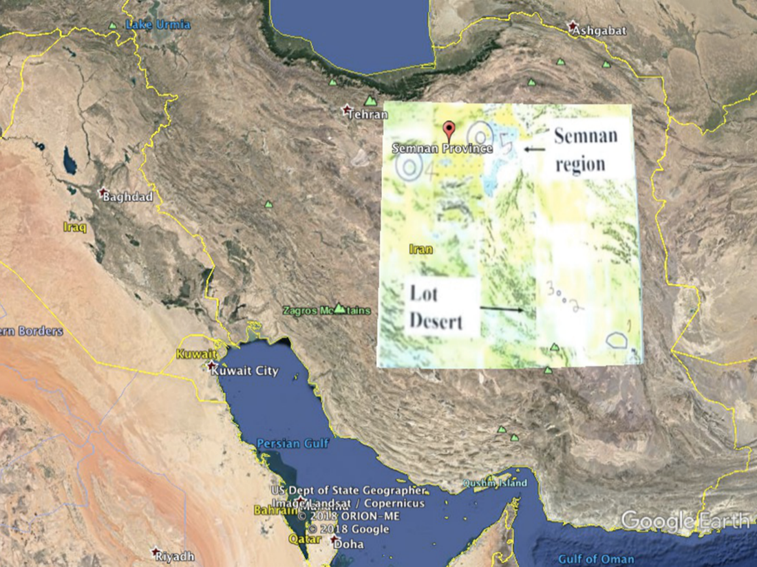
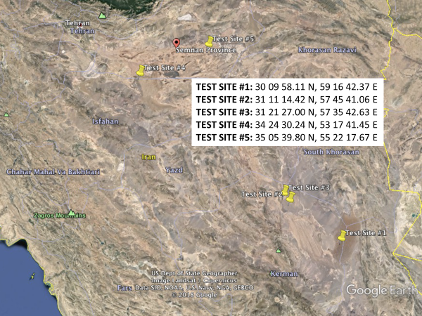
Figure 1. A document in the archive, overlain on a Google Earth image of Iran, shows the four areas (upper image) being considered for an underground test site. This was refined further to five specific locations, which are numbered 1 through 5 from south to north on the map as received by the Institute (inset, upper image). Another archive document provides the coordinates for these five sites, which the Institute used to geo-locate them in Google Earth (lower image). See Albright and Pabian, “Iran’s Investigation of Possible Underground Nuclear Test Sites in the AMAD Program prior to 2004,” Institute for Science and International Security, May 1, 2018, http://isis-online.org/isis-reports/detail/irans-investigation-of-possible-underground-nuclear-test-sites-in-the-amad/8.
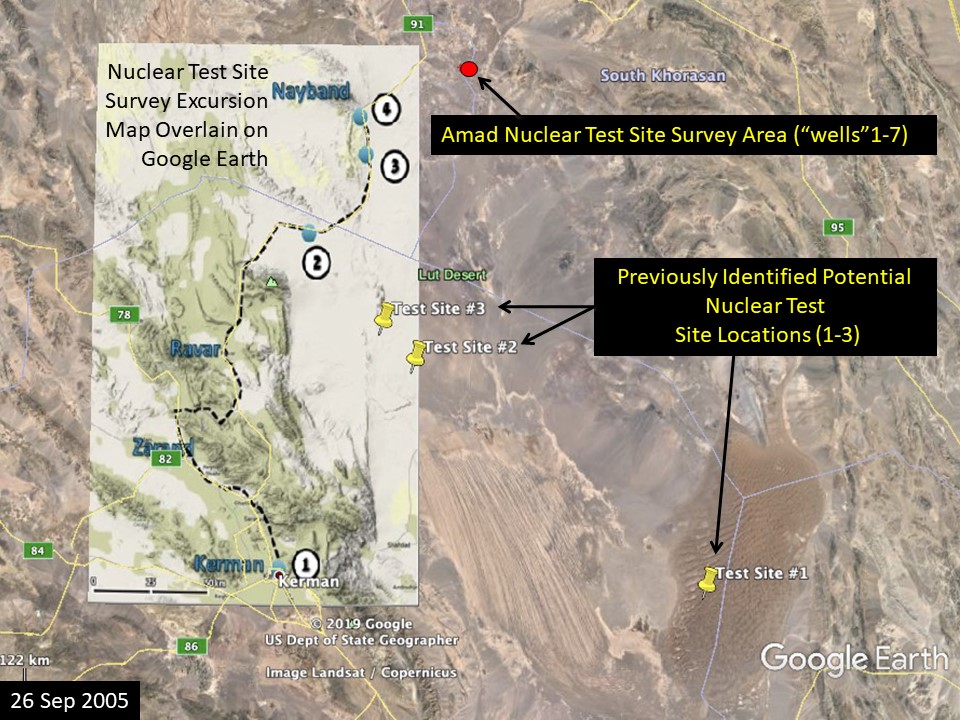
Figure 2. Route of site survey excursion/expedition, compared to location of the three previously identified potential nuclear test sites. The survey appears to have gone off-roading to the survey area after passing beyond Nayband. The route map was drawn by Israel government experts knowledgeable about the Nuclear Archive and is consistent with the order of the ground photos found in the Archive.
Figure 3. The town Nayband (image not from the archive.) The town is a culturally significant site comprised of uniquely historical architecture. https://irantravelguide.files.wordpress.com/2015/12/70cae48f106ad4241bf1f67bba565e18.jpg
Excerpt from Survey Report and Translation
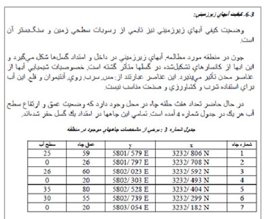
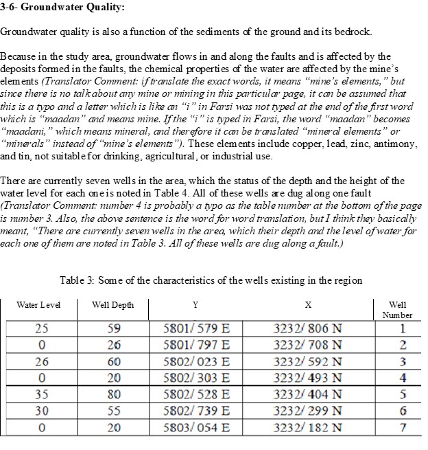
Figure 4. Excerpt of survey report and translation (with comments), showing table with seven well coordinates and water level and depth of each well.
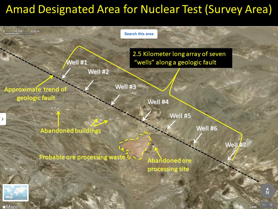
Figure 5. Overview of the seven wells and an abandoned site, likely a mine and ore processing facility.
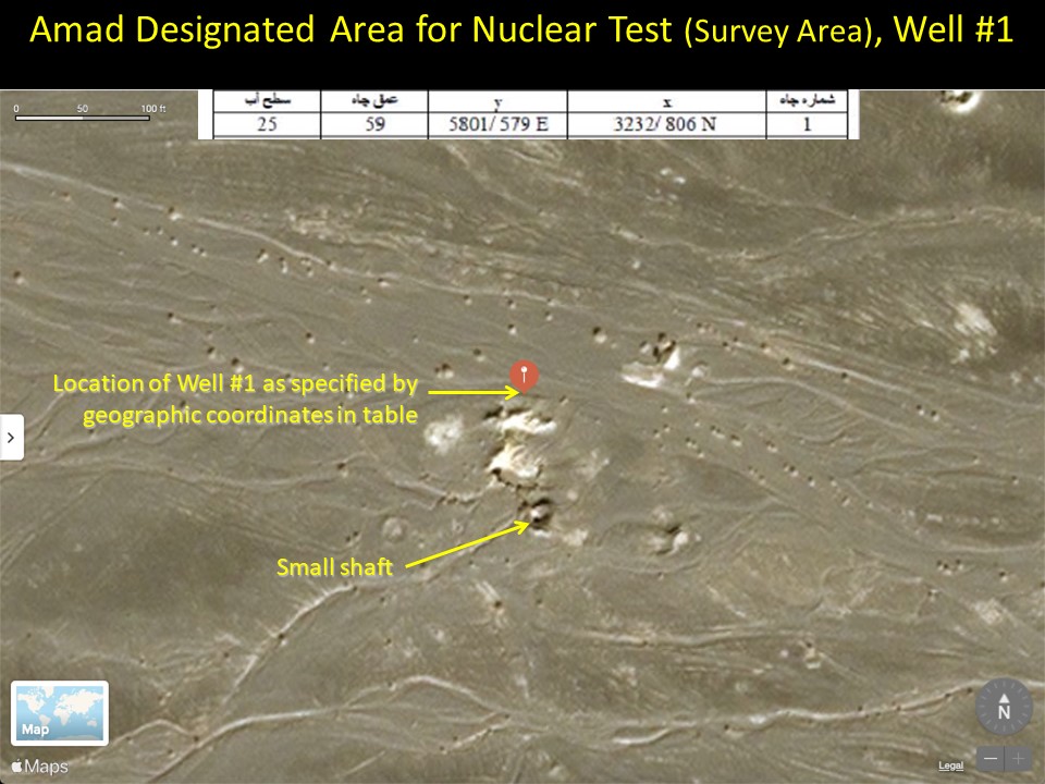
Figure 6. Well 1 in the survey area.
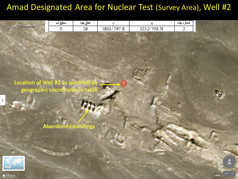
Figure 7. Well 2 in the survey area.
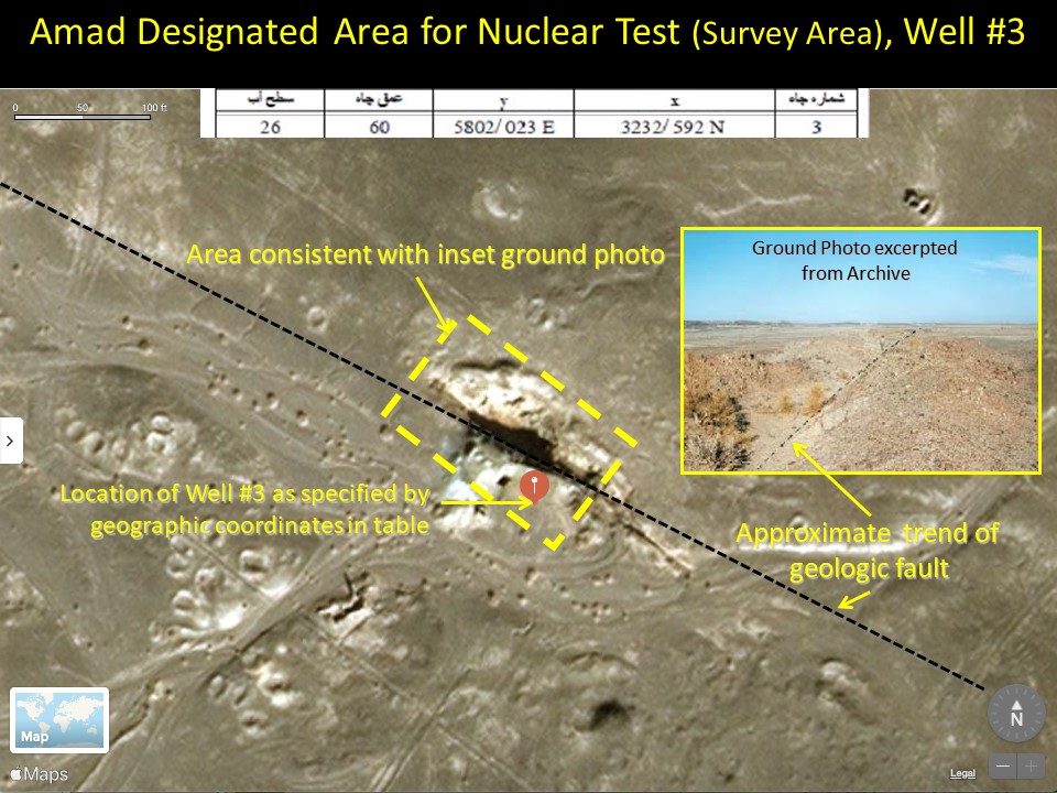
Figure 8. Well 3 in the survey area. A ground photo from the archive report also shows the geological fault.
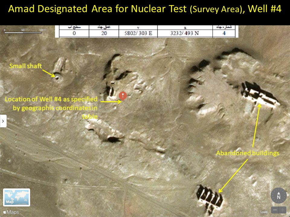
Figure 9. Well 4 in the survey area.
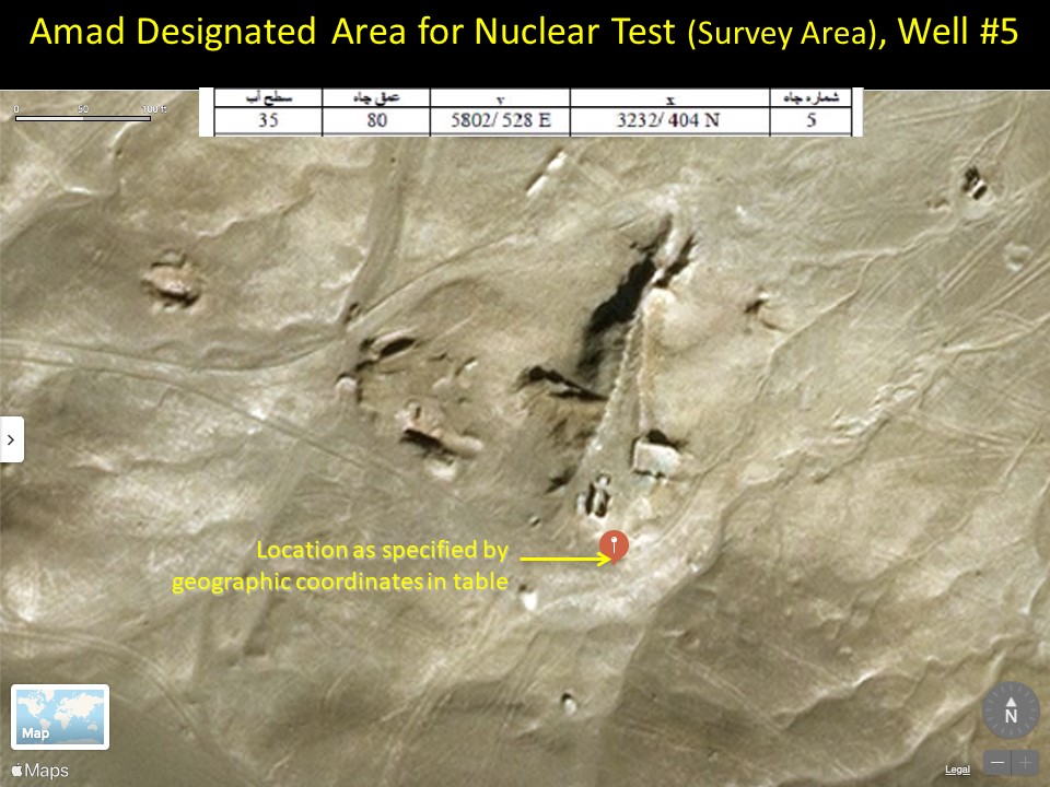
Figure 10. Well 5 in the survey area.
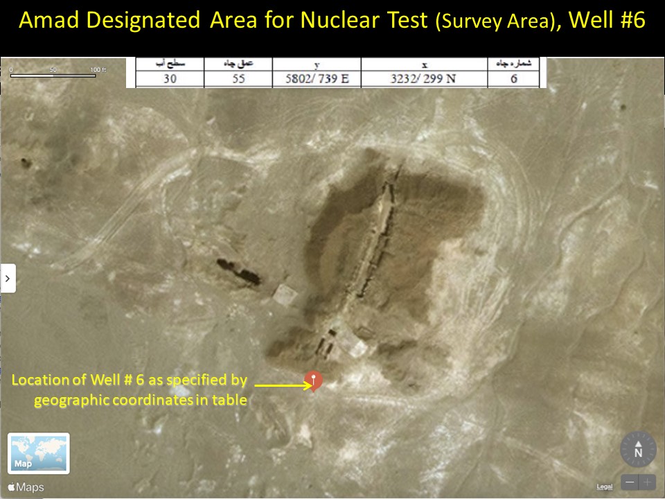
Figure 11. Well 6 in the survey area.
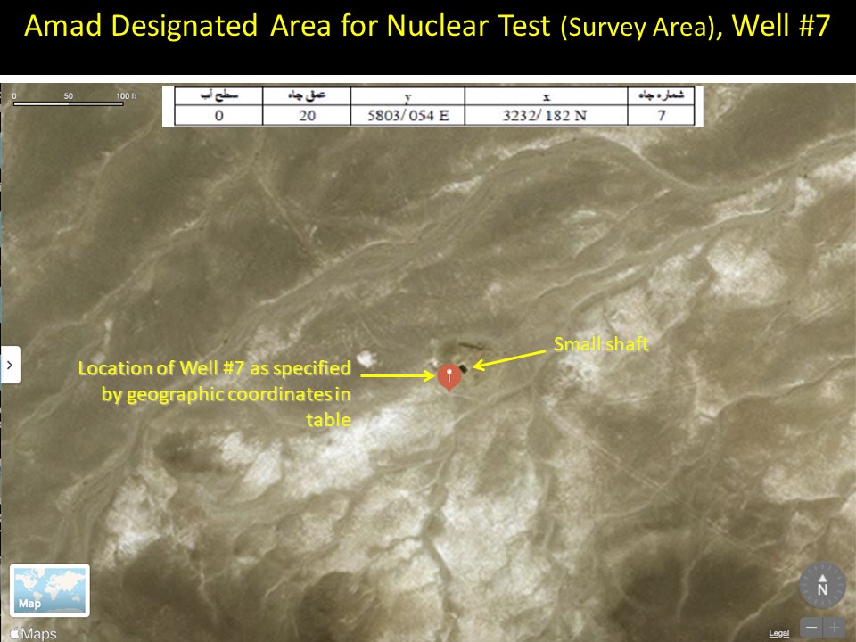
Figure 12. Well 7 in the survey area.
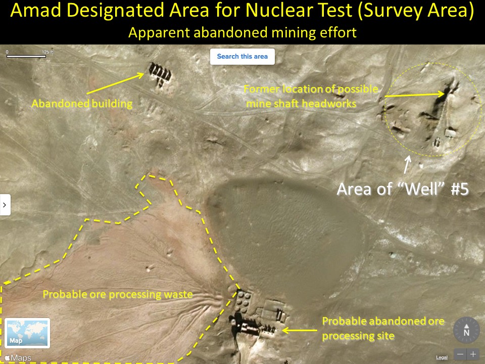
Figure 13. Area of possible abandoned mining activity near well 5.
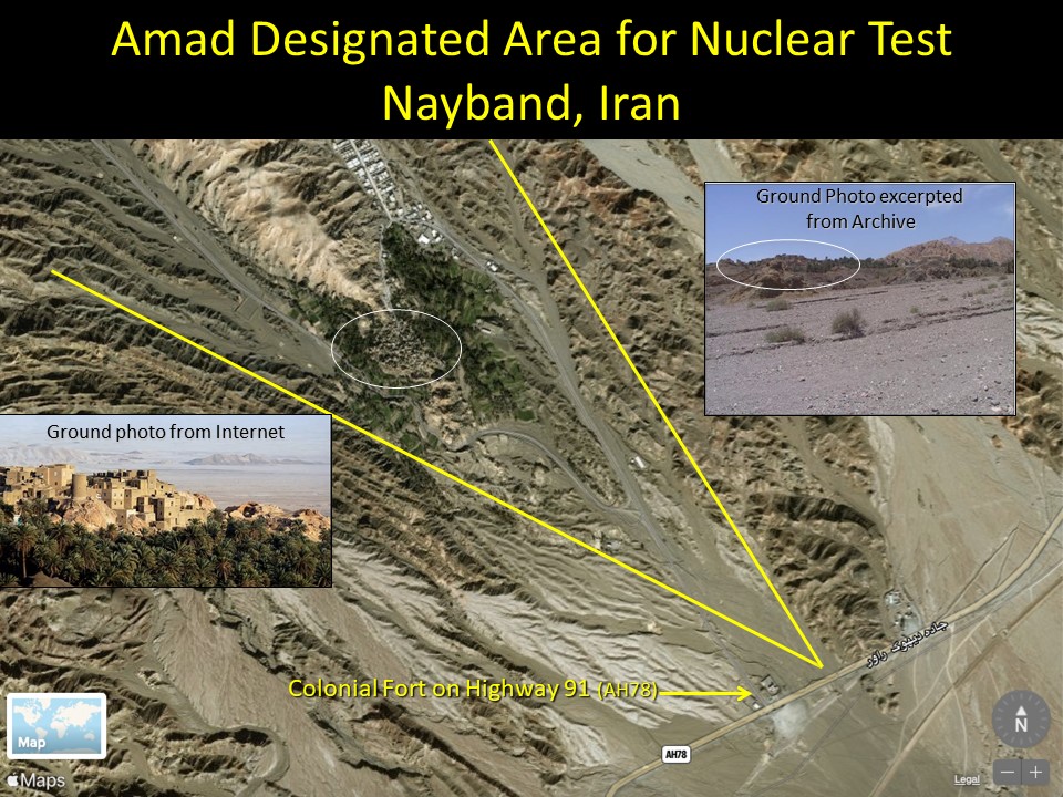
Figure 14. Nayband is visible in the background of a ground photo from the archive report.
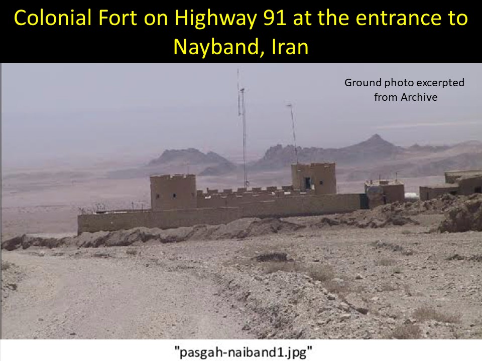
Figure 15. A ground photo from the archive shows a colonial fort with crenellated walls and towers. Two communication poles rise behind the fort. The label of the image at the bottom is on the original.
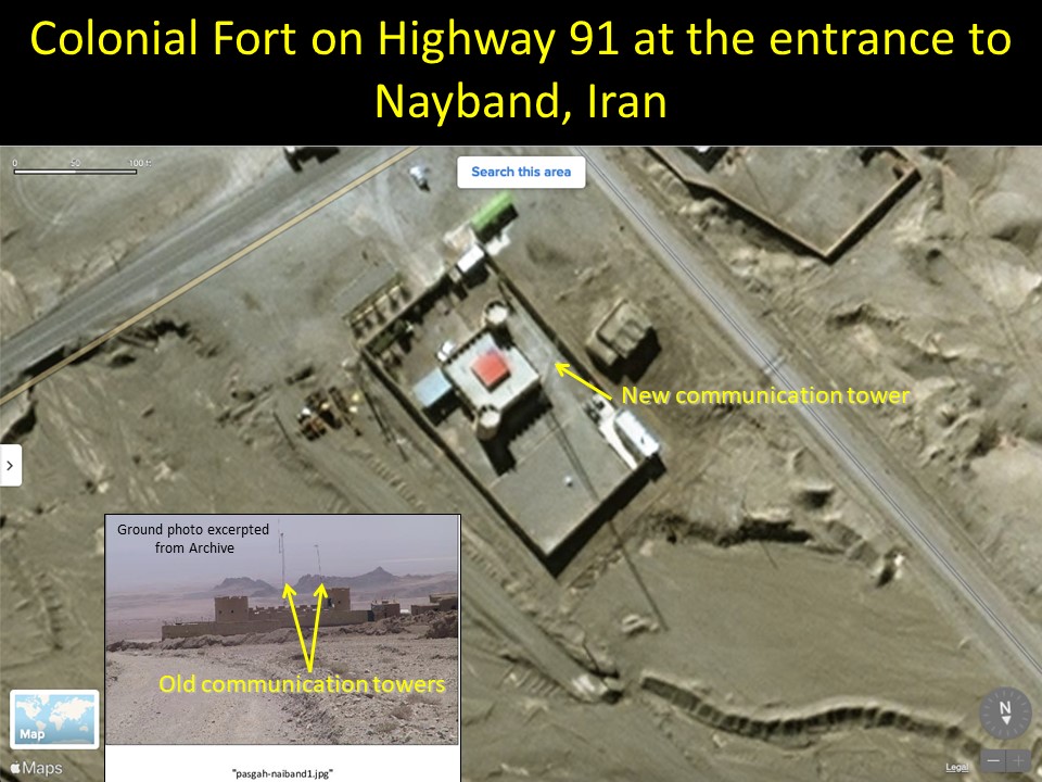
Figure 16. The colonial fort can be geo-located using commercial satellite imagery. It is located adjacent to Highway 91 near Nayband.

Figure 17. A ground photo from the archive shows rocky soil and a communication pole in the background.
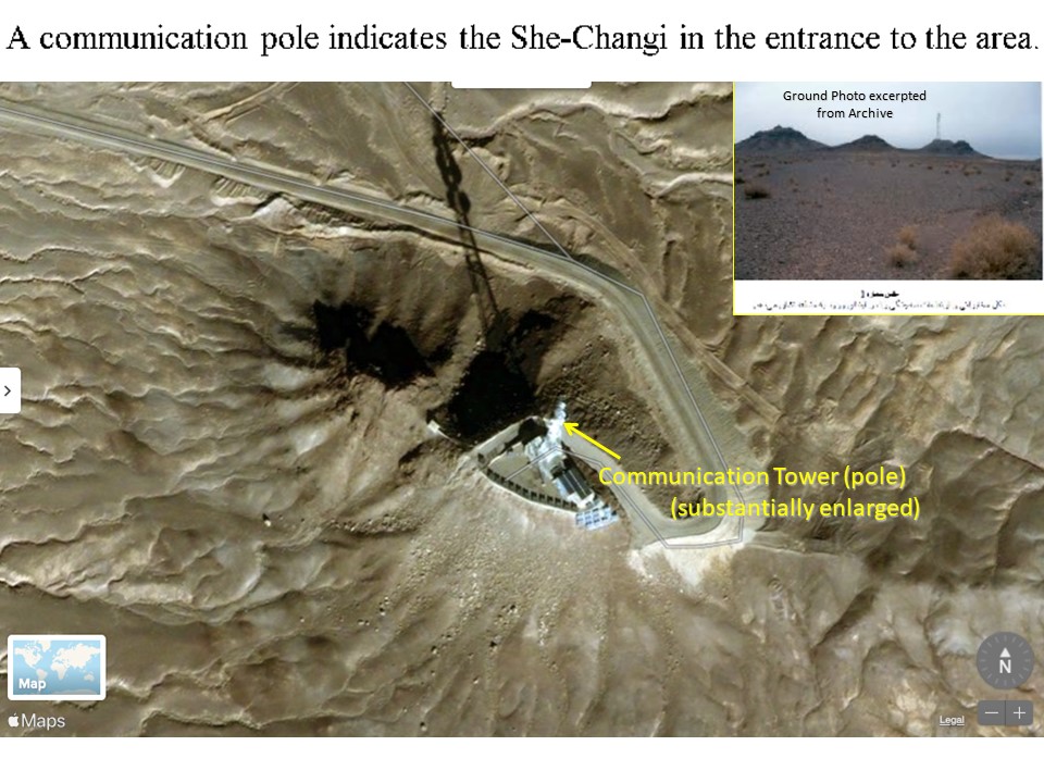
Figure 18. The communication pole can be geo-located in an Apple Maps satellite image.
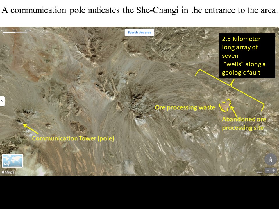
Figure 19. Satellite imagery shows that the communication pole is near the survey area.
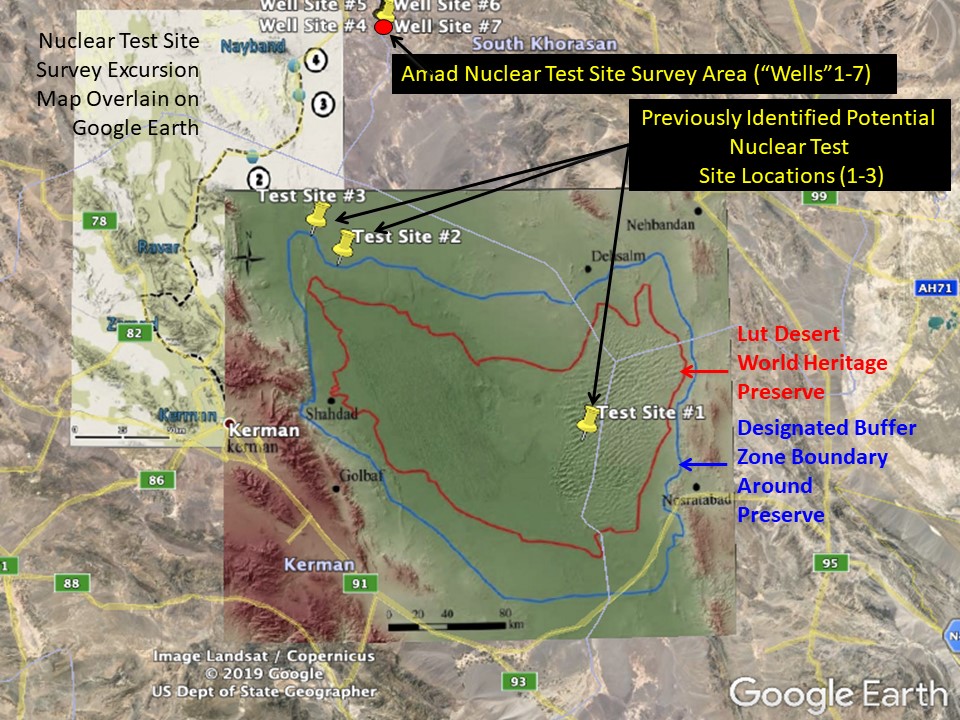
Figure 20. Google Earth image overlain map of the Lut Desert outlining the area selected in 2016 to become inscribed on the World Heritage List. While the potential nuclear test site 1 falls well within the area (red boundary), sites 2 and 3 fall immediately outside the buffer zone (blue boundary.) The seven well sites fall well outside the area, being approximately 120 kilometers to the north of the buffer zone boundary. (The other overlain map, showing the route of the site survey expedition, is described previously in Figure 2)
1. David Albright, Sarah Burkhard, Olli Heinonen, Frank Pabian, and Andrea Stricker, “Project Midan: Developing and Building an Underground Nuclear Test Site in Iran,” Institute for Science and International Security, April 2, 2019, https://isis-online.org/isis-reports/detail/project-midan-developing-and-building-an-underground-nuclear-test-site-in-i/8 ↩
2. United Nations Educational, Scientific and Cultural Organization and the World Heritage Convention, Decision: 40 COM 8B.8, “Examination of nominations of natural properties to the World Heritage List,” 2016, https://whc.unesco.org/en/decisions/6787 ↩
 email us
 twitter