Reports
Update on Alleged Explosion at Parchin Military Complex
by David Albright, Joseph S. Bermudez Jr., and Serena Kelleher-Vergantini
October 21, 2014
On October 8, 2014, ISIS published an Imagery Brief showing the possible location of an alleged explosion or fire that took place at the Parchin military complex on Sunday, October 5, 2014. Since then, ISIS has purchased and analyzed new commercial satellite imagery in order to better assess the correctness of the location of the incident and the extent of the damage.
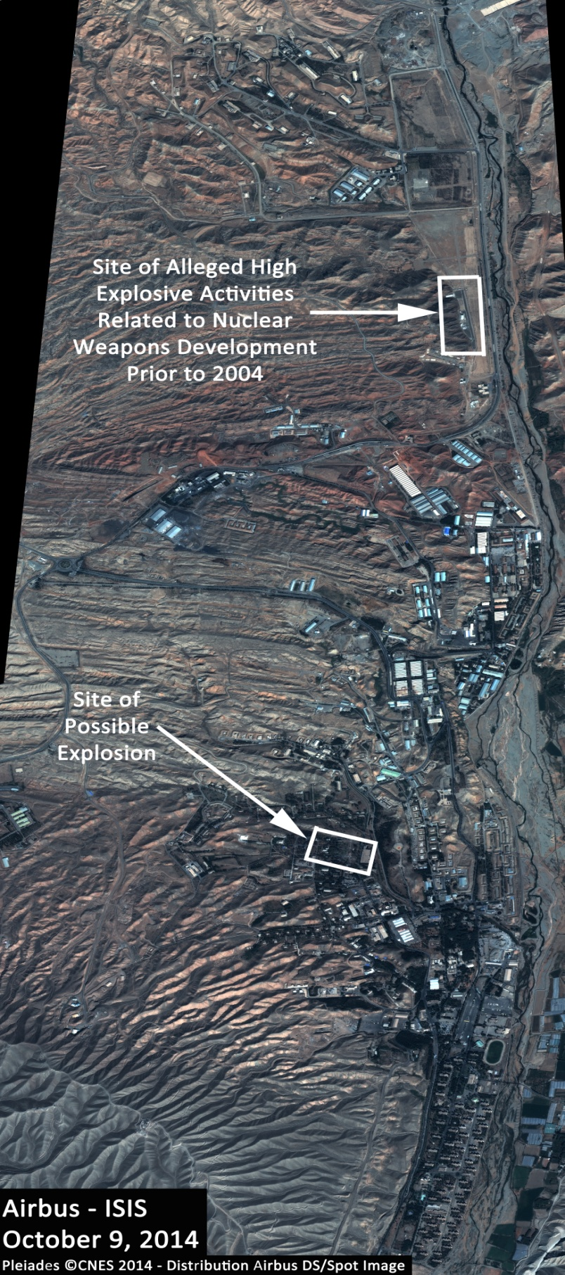
Although previous imagery only showed a section of the complex, new Airbus imagery dated October 9, 2014, shows the entire Parchin military complex. ISIS was therefore able to analyze every section of the Parchin military complex and we continue to assess that the site located in the southern section of the complex remains the most likely location of the possible explosion (see figure 1). The site is believed to be located within an area dedicated to munitions research, development, and manufacture.
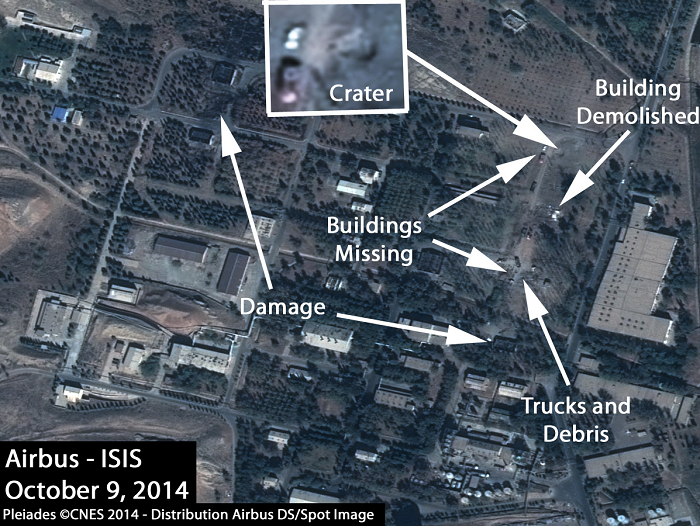
The most recent image from October 9 continues to show several signatures consistent with a major explosion and associated clean-up activities (see figures 1 and 2). The building that previously looked damaged, one that was closest to what appeared to be the central explosion or fire area, has now been dismantled. Also, at least four large trucks now appear at the site. One of these trucks appears to be a large open bed truck possibly dedicated to the removal of rubble and debris. Overall, the shape and size of these trucks are consistent with those of either fire or debris removal trucks.
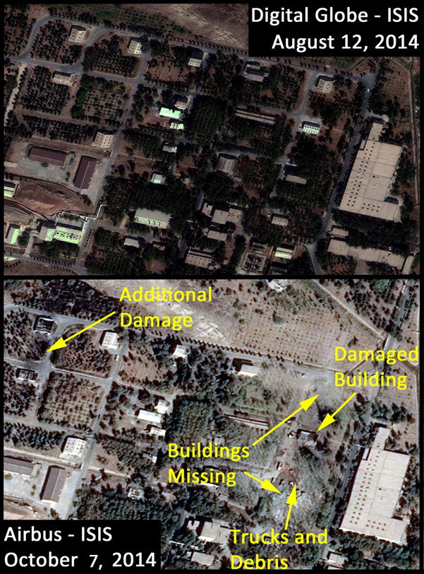
An October 7 image, the first image ISIS purchased after the reported explosion, already showed several signatures that coincided with those expected from an explosion. As figure 3 shows, two buildings that were present in August 2014 were no longer there, while a third building appeared to be severely damaged. In total at least six buildings appeared damaged or destroyed. Several trucks were already present at the site. The irregular line and color of the vegetation strongly suggested that an explosion, with a resulting fire and scattering of debris, occurred. Additionally, a layer of grey colored dust and debris was visible at the center of the probable explosion area and was scattered throughout the surrounding vegetation. Although the large building east of the main explosion area appears to present a wavy roof line, suggesting damage, as pointed out to us by an observant reader, ISIS assesses that this is an optical illusion and not an indication of any structural damage caused by the blast. The waviness is caused by a combination of the processing of the satellite image, a discrepancy with the underlying elevation data used in the image processing, the “look angle” of the satellite, and by the fact that the structure appears to be built into a hillside.
It is important to note that determining whether this damage was caused by an explosion and fire or an attack is very difficult given the little information available. Although satellite imagery from October 7 and 9 identified a single 4.5-meter-wide crater at the site of the northernmost building, imagery alone does not provide enough information to determine whether this crater was caused by the explosion, an attack, or something else. Figure 2 shows this crater, which appears about 100 meters north of what is believed to be the main explosion area. Given the proximity to the main explosion area, it is likely that this damage (and the resulting crater) was caused by post-explosion excavation or a sympathetic explosion (e.g. gas line break and subsequent explosion) rather than a bomb. It is likely that the initial explosion was generated within one building, causing the destruction of other buildings.
There is also a damaged area northwest of the main explosion site, which shows evidence of being caused by the initial explosion, either via a sympathetic explosion, flying fiery debris from the primary explosion, or fire caused by a concussion wave from the initial explosion. The area affected includes two heavily damaged buildings and an area of vegetation that seems to have caught on fire. Although as above an attack cannot be ruled out, it is not uncommon for a primary explosion to cause damage away from the original blast location.
Finally, there is no evidence of nuclear weapon-related activities at this specific site, as previously reported by other sources. These reports may have confused this site with another site at the Parchin military complex where alleged high explosive nuclear weapon-related activities occurred prior to 2004 (see figure 1). The International Atomic Energy Agency (IAEA) has asked to visit this site based upon information it received from member states and its interviews with a former Soviet nuclear weapons expert linked to this site.1 Iran has so far refused to allow the visit and in the meantime undertaken extensive building and site modifications that complicate the IAEA’s verification responsibilities under the Iran/IAEA comprehensive safeguards agreement (see ISIS reports on Parchin modification). As long as Iran refuses to allow the IAEA to visit this site, Iran will also complicate the achievement of a long-term nuclear agreement under the Joint Plan of Action.


- Bermudez is a founder of Allsource Analysis, INC., http://allsourceanalysis.com/. 1The IAEA had evidence that a former Soviet nuclear weapons expert had aided in the development of testing equipment used inside the building. See David Albright and Robert Avagyan, “Revisiting Danilenko and the Explosive Chamber at Parchin: A Review Based on Open Sources,” ISIS Report, September 17, 2012, http://isis-online.org/isis-reports/detail/revisiting-danilenko-and-the-explosive-chamber-at-parchin-a-review-based-on/8, and Mark Gorwitz, “Revisiting Vyacheslav Danilenko: His Origins in the Soviet Nuclear Weapons Complex,” ISIS Report, September 17, 2012, http://isis-online.org/uploads/isis-reports/documents/Gorwitz_Revisiting_Vyacheslav_Danilenko_17Sept2012.pdf.

 twitter