Development of the Al-Tuwaitha Site: What If the Public or the IAEA had Overhead Imagery?
During the 1970s and 1980s, the Tuwaitha Nuclear Research Center underwent a dramatic growth. In the 1980s, much of this growth involved new buildings and facilities that housed clandestine nuclear weapons-related activities in violation of Iraq’s commitments under the Non-Proliferation Treaty (NPT). This large-scale construction activity in areas well removed from the known civil facilities was visible to U.S. and Russian intelligence satellites. Although these photos could not reveal the purpose of the new buildings, they may have at least raised questions about Iraq’s intentions, if they were viewed by the inspecting authority.
The International Atomic Energy Agency (IAEA), responsible for verifying that Iraq complied with the NPT, was ignorant of the building activity at Tuwaitha. The IAEA was confined to inspecting a small set of buildings involved in declared nuclear activities. It was not provided any photographic evidence of the construction activities at Tuwaitha.
It is intriguing to speculate how the IAEA may have acted differently if it had possessed high resolution satellite imagery during the 1980s. Would the IAEA have asked Iraq about what was happening in the new buildings at the Tuwaitha site? Although the inspection rights of the IAEA were severely limited at that time, the agency had the right to conduct “special inspections” in non-nuclear weapon states party to the NPT. Armed with evidence, the IAEA would have had a legal right to request inspections of additional buildings at Tuwaitha. A refusal by Iraq to allow the inspections may have triggered greater suspicion.
What if the public and the media had had access to high resolution imagery? Press speculation was rampant that undeclared nuclear activities were carried out at Tuwaitha. More aggressive than the IAEA, the media and nongovernmental organizations may have used the high resolution imagery to single out suspect buildings as housing prohibited nuclear weapon activities.
Would Iraq have acted differently if it knew the IAEA and the public had access to such imagery? Would it have dispersed its activities away from Tuwaitha sooner, fearing that public disclosure would somehow inhibit its progress in making nuclear weapons?
We will never know the answers to such questions. But the advent of high resolution imagery forces us to address these questions now not only in the case of Iraq but other countries as well.
The IAEA now receives satellite imagery from member states. Its safeguards system has been greatly strengthened since the Persian Gulf War as a result of “Programme 93+2.” The advent of affordable high-resolution commercial satellite imagery could be a valuable tool to the IAEA under its new safeguards regime. (2)
Nongovernmental organizations, the media, and the public are already buying high resolution satellite images of sites throughout the world. With the impending launch of satellites which are designed to produce images of one-meter resolution, more groups can be expected to use satellite images. The impact of images on stopping nuclear proliferation is unclear, although these images, if assessed competently and credibily, will undoubtedly increase public awareness of nonproliferation efforts.
The first challenge is locating important sites and ordering the imagery. Because satellite imagery by itself rarely tells a compelling story, the images must be subjected to extensive analysis. Target sites must be identified on the image. Images must be interpreted. This multi-step process requires considerable information and experience about both the subject of an image and the methodology of interpreting a satellite image. This report illustrates how satellite imagery can be combined with other information, including that from “whistle-blowers” or defectors, to chart the development of clandestine activities at Tuwaitha.
The Creation of Tuwaitha
The Iraqi Atomic Energy Commission was established with U.S. help and encouragement in 1956 to foster and conduct research, development and training in nuclear science and technology. The United States donated most of the U.S. Atomic Energy Commission (AEC) unclassified reports and some nuclear detection equipment. It also encouraged Iraq to participate in the widely-touted Atoms for Peace Program, leading to the U.S. training of the first generation of Iraqi nuclear scientists.
The military coup in 1958 that destroyed the monarchy also led to a shift in the allegiance of the IAEC. In the early 1960s, the Soviet Union provided Iraq a small research reactor and other support facilities.
During this period the IAEC was structured in two units, the Nuclear Research Center and the Secretariat, which is mainly the administrative body of the IAEC. The IAEC was under the Ministry of Higher Education, which also provided office space to the Secretariat. The nuclear research center buildings were originally located in a couple of trailers next to the main Baghdad railroad station at Al-Shalchia.
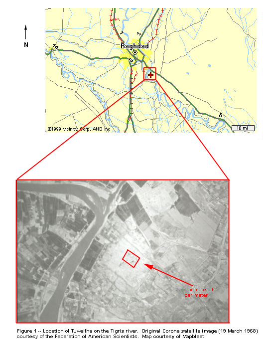
The Tuwaitha Site, located about 30 kilometers south of Baghdad, became the Nuclear Research Center when it was chosen in the early 1960s as the location of the Soviet-supplied 2 MWth IRT reactor and its associated facilities. The reactor went critical in early 1968, which marks the beginning of nuclear research in Iraq, albeit limited. The reactor commissioning was followed by an order of magnitude increase in the number of nuclear personnel in Iraq, from a few dozen to a few hundred people.
A declassified image taken by a U.S. Corona satellite in 1968 shows the Tuwaitha site near a bend in the Tigris River. The site’s security perimeter is marked (see figure 1).
The Initial Years
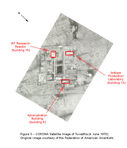
By the late 1960s, Tuwaitha was composed of several buildings. Figure 2 and Figure 3 show annotated Corona images of Tuwaitha in March 1968 and June 1970 respectively. In the first image, the Russian-supplied reactor is just going critical. In this report, each building at Tuwaitha is designated by a number as listed in Iraq’s declaration to the IAEA in 1991; Table 1 contains the Iraqi list of the buildings at Tuwaitha and their numbers as of 1991. (3)
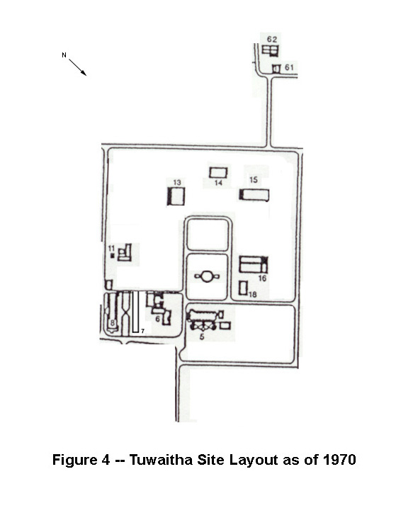
In late 1969, the site started producing radioisotopes in building 15. By 1970, the site contained the following major buildings, which are also shown schematically on Figure 4:
Building 13: The IRT reactor. This facility also contained offices for the physics and chemistry departments. An extension in front of the reactor building was completed in about 1970 to house the new IBM mainframe computer which was installed in 1973, and to house part of the Physics Department. The reactor was upgraded in 1978 to 5 megawatt-thermal.
Building 5: The first floor was the library; the top floor was for administration, including the director general of the NRC.
Building 6: Geology and Adminstration. For Uranium prospecting. This division was later moved to the Ministry of Oil & Minerals.
Building 14: Power substation.
Building 15: Isotope production laboratory (IPL). The building was later expanded.
Building 16: Workshop.
Building 18: Biology & Health Physics (top floor) .
Transition Period: 1972-1976
During this period, the nuclear weapons program was started. Its initial goal was to acquire a complete, safeguarded fuel cycle able to produce separated plutonium. The nuclear weapons plan called for making plutonium secretly in safeguarded facilities, or duplicating the facilities clandestinely and making the plutonium in these unsafeguarded plants. As part of the program’s reorientation, the IAEC was transferred to the Revolutionary Council, and in 1973 Saddam Hussein became its Chairman, a post he held until 1979 when he became President of Iraq.
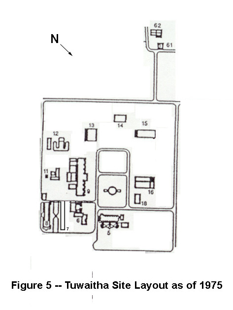
The Radiochemcial Building, or building 9, was the major addition during this period. Its design dates from the 1960s when the nuclear program was strictly peaceful. Completed in 1974 or 1975, this building housed most of the Physics and all of the Chemistry Departments. With the transfer of geology to the Ministry of Oil, the administration section moved into building 6, and the library collection was expanded considerably. Building 12 housed the engineering department, which also contained the electronics section. Figure 5 is a schematic of the site in about 1975.
Acquisition of Safeguarded Fuel Cycle Facilities: 1976-1982
In this period, extensive construction occurred in the southern half of the site, particularly in the southeastern section, that was associated with Italian and French projects. The French had agreed to supply a 40 MWth MTR reactor called Tammuz-1 or Osirak, a zero-power reactor called Tammuz-2, a materials testing hot laboratory (named LAMA), workshops, and a radioactive waste treatment station (named RWTS). The Italians supplied a research-scale radiochemistry laboratory capable of handling plutonium and an experimental fuel fabrication laboratory. Figure 6 shows a schematic of the site in about 1981 after these buildings were largely completed.
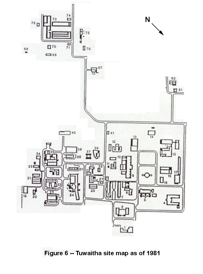
Italian project. Building 73 is a complex of several buildings, which are “prefabs” housing fuel fabrication, associated activities, and offices obtained from the Italians. The Italian-supplied laboratory-scale fuel reprocessing facility was housed in the wing of building 9 nearest to building 6. By this time, the Radiochemical Building had become the core of Iraq’s program to learn how to separate plutonium from irradiated uranium.
French project. The two French-supplied reactors were housed in building 24. The other major building built by the French was the LAMA facility in building 22. It housed facilities for fuel testing and preprocessing of spent fuel before it would be sent to the reprocessing facility or storage. The French contract also included the construction of a large number of offices and laboratory facilities near the reactor, and the RWTS in building 35.
In June 1981, Israel bombed the Tammuz-1 reactor, destroying it before it could operate. Israel feared the reactor would produce weapon-grade plutonium in secret. One of us (Hamza) was involved in planning the effort to produce plutonum clandestinely in this reactor and to defeat IAEA safeguards.
An unexploded bomb was found in a 30-50 meter-long tunnel that connected the reactor to an experimental hall, which was designed to conduct experiments with neutrons produced in the reactor. Iraqi scientists received media reports at the time that speculated Israel believed that the tunnel may have been intended for reprocessing, which was not in fact the case.
Other construction. Building 7 was added for administration. The biology department moved into building 4.
Covert facilities: 1982-1991
In 1982, Iraq created the new Office of Studies and Development (OSD, later renamed PC-3) to pursue secret uranium enrichment and weapons activities, appointing Jaffar Dhia Jaffar as its head. This decision led to a major expansion of Tuwaitha, particularly to the west of the old nuclear research center. In addition to the need for highly classified areas, the new program wanted to have many of its buildings physically removed from the rest of the complex but close enough for services and support.
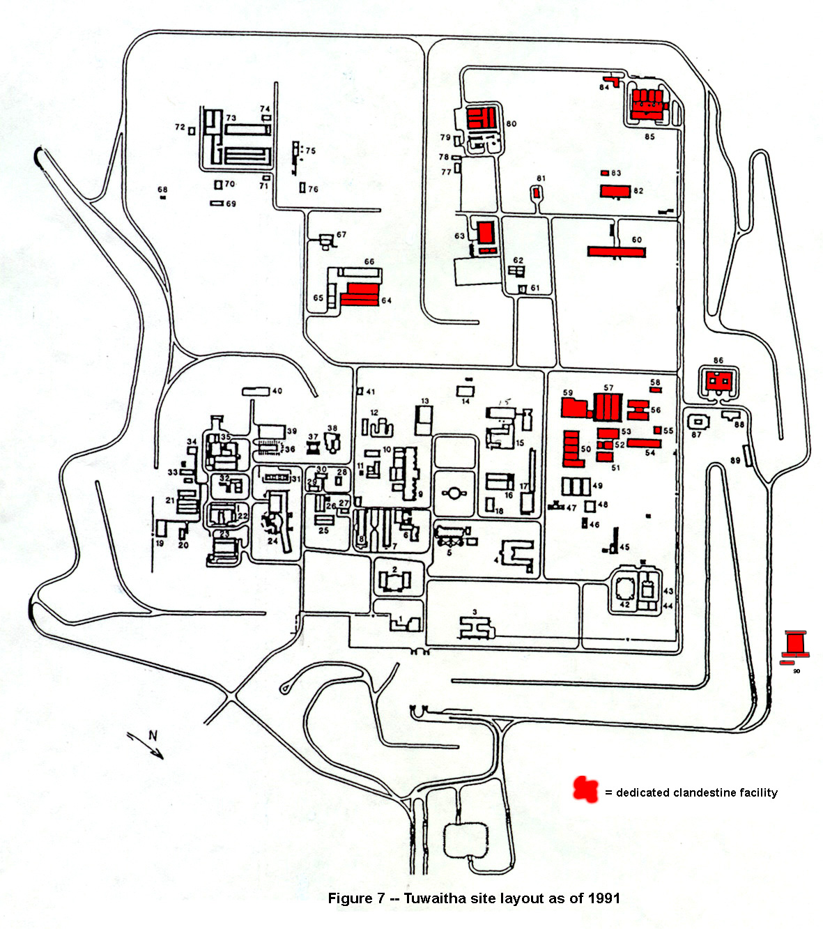
Figure 7 shows Tuwaitha schematically in 1991, where the dedicated, clandestine facilities are shaded. Weapon-related activities occurred in many other buildings, but the shaded buildings are those where little but undeclared activities occurred.
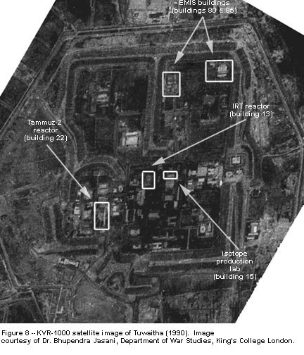
Figure 8 is a Russian, two-meter KVR-1000 satellite image of the Tuwaitha site taken in 1990. The buildings represented in figure 7 can be identified. The berm is also visible.
Pending the completion of new buildings, OSD intially installed its secret electromagnetic isotope separation (EMIS) uranium enrichment program in building 73, which is in fact a complex of facilities. This complex also housed the newly created materials science division which focused on the development and testing of the gaseous diffusion barrier. At this time, Iraq developed procedures to limit access to these buildings by IAEA inspectors who had a right to inspect the fuel fabrication facility. On days when inspectors were scheduled to visit, only the fuel fabrication rooms were open to them. Usually, employees were told to take the day off or stay in their rooms so that the inspectors did not see an unusually large number of people.
In 1981, building 82 (perhaps called 61 originally) was intended to house laser isotope separation (including uranium). This effort was always envisioned as a clandestine activity and thus built away from other buildings. The OSD, however, utilized this building for the new electronics departments and the portion of the gaseous diffusion department that focused on theoretical and design work. The laser enrichment section instead moved into building 23, the old laboratories for the Tammuz-1 reactor. (The gaseous diffusion program was never located in building 23, as declared by Iraq in 1991.)
In 1982, building 63 was finished. The materials science section moved from building 73 to this building.
New buildings were subsequently added in the northwest section. Building 80 was finished in about 1982 or 1983 and housed the EMIS program. In 1984, building 85 was finished; it was originally designed for the development of the gaseous diffusion separating stages and EMIS chemistry. In 1987 when the gaseous diffusion project was de-emphasized, building 85 and building 84 were used mainly for EMIS chemistry.
Building 60 was finished in about 1984 to house engineering offices and labs for the electronics department, particularly control and high voltage engineering for EMIS. The EMIS program required a considerable expansion of the machine shops. As a result, a new complex of buildings 50 to 57 was gradually built.
Building 59 was required to house the new enlarged Safety Division of OSD. A Health Physics section was included in this division.
Building 86 was built to hold the growing number of mechanical design teams, which were under the OSD, although they continued to do some work for the civil nuclear program..
Building 64 was built to house a uranium metallurgy project and a new polonium laboratory for the development of neutron initiators for a nuclear explosive. In its listing of buildings (see table 1), Iraq deliberately misidentified the pupose of this building. Building 66 was a row of offices used by the neutron initiator project personnel. Building 65 was unused at the time of the bombing.
Building 90 was built in the late 1980s outside the berm to research and develop chemical uranium enrichment processes. Initially, chemical enrichment work was performed in buildings 9 and 10 and then in building 85.
Within the zone of the old nuclear research center, building 3, which was built in the mid-1980s, temporarily housed the Projects Administration for all nuclear projects. In late 1987 or early 1988, Group 4, which was responsible for weaponization, moved into this building or an adjacent one.
A trailer on land that later became building 3 was Jaffar’s first headquarters in late 1981 or early 1982. He then moved into a new building next to building 8, which housed the International Relations Division and the training offices. Jaffar stayed in this building until he moved into the Ministry of Industry and Military Industrialization in Baghdad in the late 1980s.
Other activities.
After the destruction of the Tammuz-1 reactor by the Israelis in 1981, building 24 was renovated to house the physics divisions, chemistry departments, and reactor engineers and operators, which comprised the traditional civilian functions of the nuclear research center. (In 1990, the basement of this building was used to house the dense plasma focus device, which was supplied by Poland with the help of the IAEA.) In the early 1980s, an addition to building 12 was built to house the French-supplied neutron generator, which was used for civilian research and subject to IAEA visits. Buildings 87 and 88 were created as medical facilities for all Tuwaitha employees.
Buildings 42-44 were built by a Yugoslav company as library and conference facilities. Building 5 was expanded and renovated to house the Atomic Energy Commission’s Chairman and his staff.
Post-War Activities
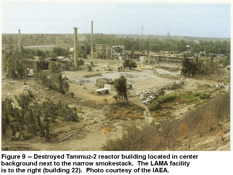
The Tuwaitha site was extensively damaged during the allied bombing campaign in early 1991. Figure 9 shows the destroyed Tammuz-2 reactor building.
Figure 10 is a Russian, two-meter KVR-1000 satellite image of the Tuwaitha site taken in December 1991. Extensive bomb damage and subsequent Iraqi demolition can be seen.
Following the bombing of the Tuwaitha site, Iraq also razed several buildings to hide evidence of secret uranium enrichment activities from the inspectors. Buildings 80 and 85, which housed EMIS activities, had been heavily damaged by the bombing, and both were subjected to unusually extensive site clearance by Iraq in a failed attempt to prevent inspectors from learning about the true purpose of the buildings. In the case of building 80, which housed EMIS separators, Iraqis removed the equipment in the building and took out the substantial concrete reinforced floor, and regraded the site to a level field. Building 85 was likewise stripped of equipment, and the site was razed. These razed areas are identified in the KVR image in Figure 10.
(1) We would like to thank Charles Vick at the Federation of the American Scientists for providing us with high-quality images from the U.S. Corona satellite program, which was the first intelligence agency spy satellite program, now declassified. We would also like to thank Dr; Bhupendra Jasani of the Department of War Studies, Kings College, London for providing a KVR-1000 image.
(2) The IAEA is currently evaluating the role of commercial satellite imagery. See for example, IAEA Technical Workshop, Safeguards: Sources and Applications of Commercial Satellite Imagery, Vienna International Centre, September 16-17, 1998, Working Documents, Division of Safeguards Information Technology, Department of Safeguards.
(3) See Annexes 1 and 2, IAEA Action Team, Consolidated Report on the First Two IAEA Inspections Under Security Council Resolution 687 (1991) of Iraqi Nuclear Capabilities, July 11, 1991. A few buildings may be missing from the map (see figure 7 and figure 9), or accidentally misidentified in the list of building (see table 1). For example, there is a long building adjacent to building 3 that is not included on this map. In the list of buildings (see table 1), Iraq also deliberately misidentified several facilities to disguise their true purpose. Because additional information to identify the actual purpose of the buildings is used in this analysis, the map and key are sufficient for the purposes of this report.