Reports
Monitoring Activity at Punggye-ri Nuclear Test Site*
by David Albright and Robert Avagyan
February 3, 2013
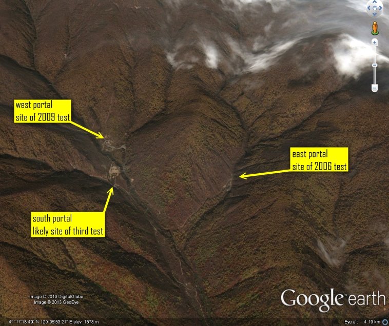
On January 24, 2013 North Korea released a statement claiming that it intended to conduct a third nuclear test. The North Korean statement coincided with reports from several government, media, and nongovernmental sources that activity at a site in the Punggye-ri test complex indicated increasing readiness for testing. The test complex is the location of North Korea’s two previous nuclear tests, conducted in 2006 and 2009. An August 2012 report by Frank Pabian and Siegfried Hecker published in the Bulletin of Atomic Scientists combined several studies using seismic data and satellite imagery analysis to closely approximate the geographic locations of the previous tests and predict the location for a potential third test as suggested by a new tunnel excavation started in the spring of 2012.
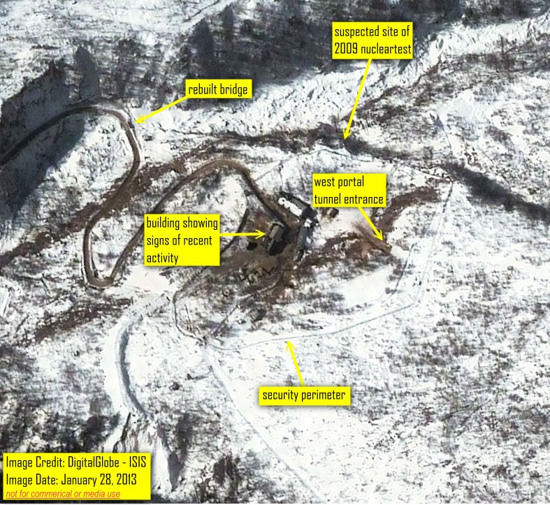
ISIS obtained Digital Globe satellite imagery from January 28, 2013 which confirms reports of activity at both the site of the new tunnel, designated as the “south portal” in the Bulletin of Atomic Scientists article, and the tunnel used in the 2009 test, designated as the “west portal” in the article (see figure 1). Although the images do not reveal whether a test is imminent, the on-going activity at the site justifies concern that a test will soon occur.
South Portal
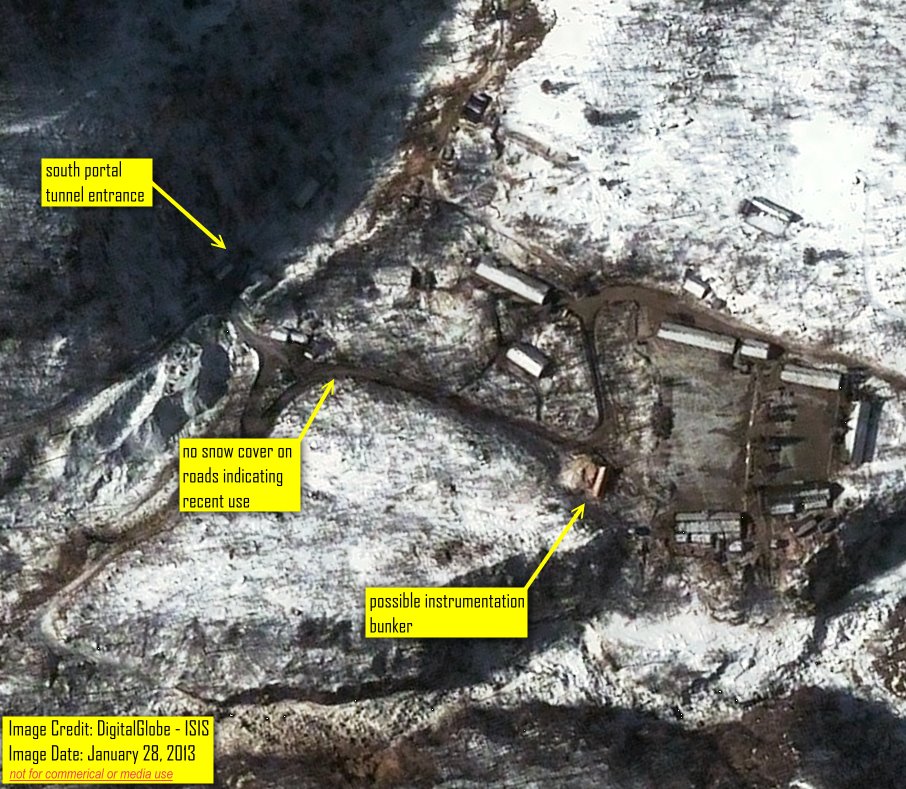
Activity at the site of the new tunnel, the south portal, has been consistently documented by the 38North website reports and the latest imagery obtained by ISIS suggests no obvious change in the level of activity portending an imminent test (see figure 2). The fact that the grounds of the compound and nearby roads are cleared of snowfall, however, indicates continued activity. A few buildings have no snow on their roofs, suggesting that the buildings are actively being used.
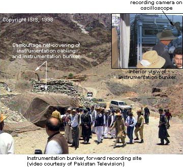
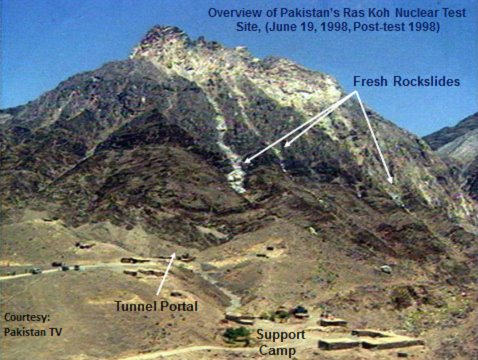
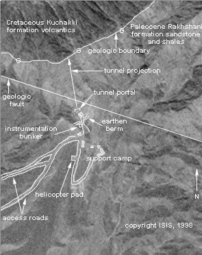
A building located approximately 150 meters from the south portal tunnel entrance appears to be shielded by a berm making it the likely location for a bunker (figure 2). The exact purpose is not known. However, it could contain instrumentation to record the effects of a nuclear explosion and communication equipment that would relay the data to a center located at a safe distance from the test site (figure 2). An instrumentation bunker was located similarly in the case of Pakistan’s 1998 nuclear test (see figure 3), and prior to the test, personnel were evacuated to a safe distance from the test site. 1
In the Pakistani case, the instrumentation bunker, or forward recording site, was camouflaged and located approximately 120 meters from the tunnel portal (figures 3 and 4).
The site layouts of the 1998 Pakistani test site and the North Korean south portal site have similarities, despite the greater camouflaging by Pakistan (compare figures 5 and 6 with figure 2). 2 In the 1990s and early 2000s, Pakistan and North Korea closely cooperated on gas centrifuges and missiles. North Korea may have benefited from Pakistan’s nuclear testing experience and data.
The firing control center for the test site could not be located. However, it is likely located several kilometers away from the south portal in order to adequately protect personnel from earth accelerations produced by the explosion and in the event of any accidental releases of radioactivity after the explosion.
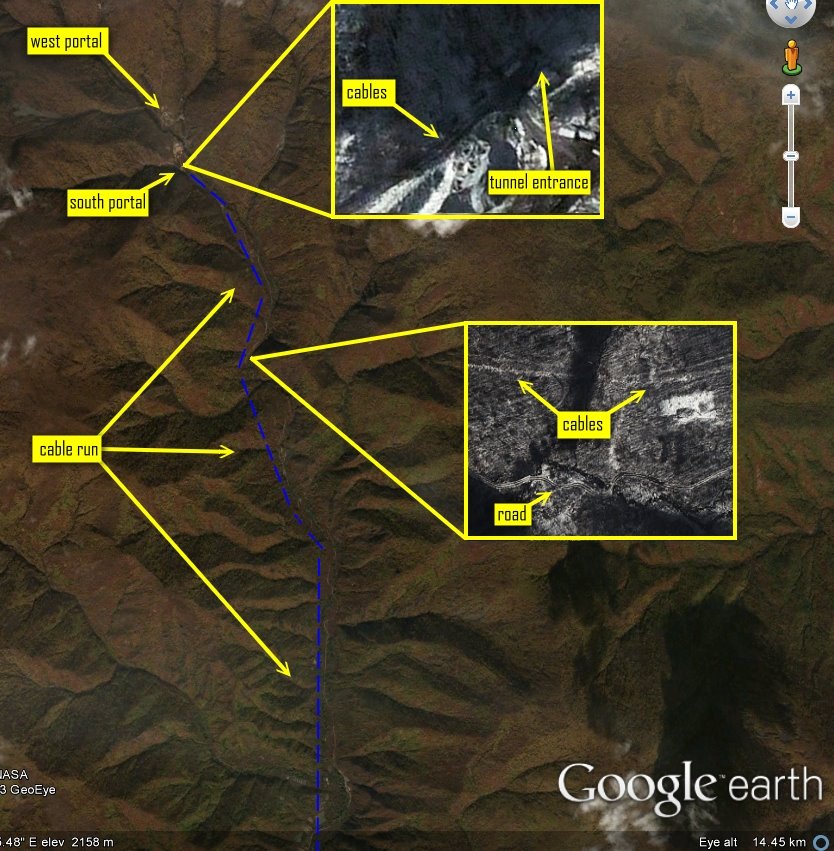
ISIS identified what could be a cable run in images extending from the direction of the south portal tunnel entrance southward for many kilometers (see figure 7). The suspected cable run could be for electricity or communication.
West Portal
At the west portal, the January 28, 2013 image shows activity at the tunnel entrance. It suggests that some kind of traffic has been going in and out of this tunnel. The road leading to the 2009 test tunnel site shows signs of consistent traffic as suggested by the lack of snowfall within the perimeter of the site and connecting access roads (figure 8).
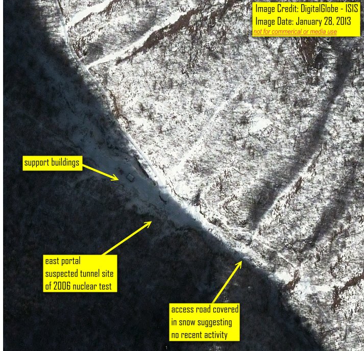
North Korea has also taken steps to keep both the west and south portals accessible; it has not tried to keep accessible the site of the 2006 test, the east portal, which in the latest satellite imagery appears inactive (figure 9). Extensive flooding damaged bridges leading to the west and south portals during a September 2012 storm, but North Korea quickly rebuilt them.
The purpose of the activity at the west portal is unclear from the image, and the reuse of the tunnel for a full-scale nuclear test cannot be dismissed. It should be pointed out that the west portal compound has a complete security perimeter, and the south portal does not. The existence of this security perimeter suggests the possibility that sensitive activities could be occurring inside the west portal tunnel.
Another unknown is where North Korea would prepare its nuclear test device for subsequent detonation in the south tunnel. It could be in a secure facility, perhaps located a distance from the portals. Alternatively, nuclear device preparation could occur in the tunnel at the west portal prior to transport to the south portal for detonation. In that Pakistani 1998 Ras Koh test site case the final device assembly occurred in “zero rooms” within the tunnel itself in which case detection from overhead imagery would be unlikely unless the delivery and unloading process were to be captured. 3
For licensing and use of the DigitalGlobe satellite imagery presented below see the following links: South portal image January 28, 2013 West portal image January 28, 2013 East portal image January 28, 2013
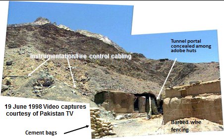
- ISIS would like to thank DigitalGlobe’s Analysis Center for their assistance. 1. ISIS, “New Details Emerge on Pakistan’s First Nuclear Test Site,” EOM (Earth Observation Magazine), December 98/January 99. 2. It should be noted that the Pakistani test site in the Ras Koh was a secret site while the North Korean test site is not. Nonetheless, a comparison of the two test sites is instructive. North Korea does take steps to camouflage some of its activities there but not the site itself, as Pakistan did with its nuclear test sites up to its 1998 tests. The following is a description of the camouflaging at the Pakistani site by Rai Muhammad Saleh Azam, Where Mountains Move: The Story of Chagai: “All the installations including the tunnel portals and the instrumentation and fire control cables leading into the tunnel shafts were camouflaged using canvass and net. The facilities were made to look like a small hamlet using adobe huts so as to deceive satellite surveillance. The tunnel portal itself was located inside an adobe hut. Barbed wire was placed around all the facilities so as to minimise the number of tracks and to keep pedestrian and vehicular movement on designated tracks. Vehicle tracks caused by incoming and outgoing trucks and jeeps were continuously erased by a team of soldiers assigned to the task. Support camps were established a few hundred yards away from Ground Zero at both the sites. These included lodging, food and water, restroom, shelter and communications facilities. These too were camouflaged. At Ras Koh, these support facilities were located directly south of the mountain in which the shafts had been bored.” Found at http://www.pakdef.info/pakmilitary/army/nuclear/wheremountainsmove.html 3. Ibid
 email us
 twitter