Reports
Is the facility at Qusayr, Syria an underground nuclear facility? Public Evidence remains inconclusive
by David Albright, Sarah Burkhard, Allison Lach, and Frank Pabian
March 21, 2018
Lede and Commentary
The Institute decided to revisit a series of claims made in a 2015 Der Spiegel report regarding the Qusayr site in Syria, including that the site could be the location of an underground nuclear reactor or uranium enrichment facility, or could contain nuclear fuel from Syria’s destroyed Al Kibar nuclear reactor.1 Based on commercial satellite imagery, none of these claims could be confirmed, and the purpose of the site remains unknown. However, some imagery observations are consistent with Der Spiegel’s reporting. Although we fully understand the limitations and risks of the following approach, we believe that this site warrants inspection by the International Atomic Energy Agency (IAEA), even though accomplishing such inspections may have to wait until the Syrian conflict ends. Any nuclear-related facility in Syria could involve considerable assistance from North Korea, given that Pyongyang provided extensive assistance in the construction of the Al Kibar reactor, which Israel destroyed in 2007. Israel’s recent decision to declassify that it had indeed destroyed this reactor also includes documents explaining that it had strong evidence of North Korean involvement in the reactor project.2 Israel’s action serves to highlight once again the lack of accounting for Syria’s past nuclear weapons program and the location of any assets remaining from that program. This includes possibly tens of metric tonnes of uranium fuel, and other equipment or materials associated with nuclear fuel fabrication and plutonium separation, that likely existed as key elements of the Al Kibar reactor project. Understanding North Korea’s role in Syria is also important as the United States weighs the prospects of negotiations with North Korea. The United States and its negotiating partners must keep in mind that any negotiation should include the achievement of verifiable commitments by North Korea not to undertake nuclear, chemical, or biological proliferation and not to spread the means to deliver them. It should also include longer term commitments by North Korea to explain and resolve the nature and extent of its nuclear cooperation with Syria and any other countries.
Introduction
A recent United Nations Panel of Experts report on North Korea states that North Korea has shipped critical supplies to Syria that could be used in its chemical weapons program.3 North Korea has also provided extensive assistance to Syria’s ballistic missile program. A February 2018 report by Fox News indicates that Iran reportedly established another military base in Syria that includes missile storage.4 In the early 2000s, Syria and North Korea undertook significant nuclear cooperation. North Korea supplied Syria with a plutonium production reactor built at Al Kibar, as well as support staff and potentially other nuclear-related facilities and assistance. Syria took a number of steps to disguise from overhead satellites the site’s actual purpose.5 The reactor was well-hidden and camouflaged, including building it partially underground. The North Korean-built reactor was destroyed in 2007, by an Israeli airstrike.6 Syria has consistently denied that the Al Kibar site was a reactor, despite IAEA findings to the contrary. An enduring mystery, often reported on by the Institute for Science and International Security, is the fate of key remnants of the reactor project, such as stockpiles of natural uranium, fuel fabrication capabilities, and even possibly plutonium separation capabilities that may have remained in Syria and continue to pose a proliferation risk.7
With many reports of North Korea and Iran providing military, missile, chemical weapons, or nuclear assistance to Syria, the Institute decided to use commercial satellite imagery to look at a claim that was first publicly made by Der Spiegel in January 2015. Der Spiegel suggested the possibility of yet another hidden nuclear site in Syria: an underground nuclear-related site in Qusayr.8 The report has not been confirmed as of today, and the purpose of the site remains unknown.
Assessment of Der Spiegel Claims
Der Spiegel in 2015 made a series of claims regarding the Qusayr site, allegedly based on intelligence information. Many of the claims could not be confirmed or denied using public information, but some imagery observations are consistent with Der Spiegel’s reporting. Although we fully understand the limitations and risks of this approach, we believe that this site warrants inspection by the IAEA. Moreover, any negotiation with North Korea has to have, as a high priority, verifiable commitments by North Korea not to undertake nuclear, chemical, or biological proliferation and not to spread the means to deliver them.
Claim 1: There is an underground site at Qusayr.9 According to the report, construction began in 2009. No Google Earth imagery is available from those dates, but later commercial satellite imagery shows large amounts of excavated limestone earth (Figure 1, discussed below). The excavated material was transported away from the immediate vicinity of the central area and subsequently camouflaged, showing significant efforts to hide the underground site.
Claim 2: 8,000 fuel rods are stored at the underground site at Qusayr. This information could not be confirmed by the Institute, but the existence of natural uranium in Syria remains likely and a concern.
Claim 3: The site hosts a guard house and five additional buildings. This can be confirmed using satellite imagery (Figure 2, discussed below).
Claim 4: Three of the buildings conceal tunnel entrances. This could not be directly confirmed. However, three buildings are butted up directly against the hillside, consistent with such alleged underground access. The buildings have a size of approximately 25 x 15 meters.
Claim 5: The site is connected to a power grid. This could be confirmed using satellite imagery. Based on the size of the power poles, our estimate of the incoming powerline is about 11 to 33 Kilovolt Amperes (kVA).
Claim 6: A well connects the site with a nearby lake for water supply. The connection to the lake could not be confirmed, but the location of the well as labeled in a Der Spiegel graphic included with the story seems correct given that a probable mobile drill rig was imaged at that location in July 2012. The shape of a mobile drill rig is discernible on satellite imagery viewable on Google Earth (Figure 8, discussed below). Also, according to hydrological surveys, the site appears to be situated above a shallow but large volume aquifer.10 A reactor could be cooled using ground water, and this site appears to have adequate groundwater to do the cooling. Such a strategy, while unusual, would be consistent with Syrian efforts to suppress observable signatures, such as Syria did at the Al Kibar reactor. While somewhat speculative, one possibility that has not been adequately considered is that Syria could have employed, or at least intended to employ, ground water cooling using injection of the heated water back underground, and thus the reactor’s cooling system could be entirely hidden. Such a concept is not unprecedented, given the fact that the 20-megawatt thermal (MWth) SM1A reactor located at Fort Greely, Alaska, drew its cooling water from a deep well and recharged the condenser outlet back underground via a dry well.11
As for the purpose of the site, according to Der Spiegel, it has previously been identified as a Hezbollah conventional weapons storage facility. In 2012, IHS Jane’s identified it as a SCUD missile site. Based on the claims laid out above, Der Spiegel speculated that the site could be for a nuclear reactor or an enrichment facility. The Institute assesses the site as military-related and suspicious. Without further information on the power supply, the alleged connection to the lake or underground water supply, the means for water intake and discharge, ventilation system, security measures, size of the underground facility, and on-the-ground information from defectors or international inspectors, no firm conclusion can be drawn about potential nuclear-related activities at the site.
Commercial Satellite Imagery Analysis of Qusayr
Figure 1, a November 28, 2017 DigitalGlobe image acquired by the Institute, provides an overview of the underground facility and its environment. It shows unprecedented effort to camouflage the excavated white limestone spoil by dispersing it down the valley along terrain and geologic bedding contours, and subsequently covering the white limestone material with brown earth. The figure also shows the connection to the power grid (See claims 1 and 5 of Der Spiegel).
Figure 2 is a close-up image of the central site, showing three buildings reportedly hiding underground entrances and some of the site’s security measures (claim 3). While vehicles parked outside the underground entrance buildings indicate vehicular activity, the site itself has only changed slightly over the past four years. Using a Google Earth image from March 2014 for comparison (figures 3 and 4), changes occurred in the central area outside the underground entrance buildings, and vehicles are visible parked near the security checkpoint and the main Buildings.
It is unknown who may have dug the underground facility. However, North Korea is known to export its mining and excavation expertise to countries such as Syria. A recent Homs media report reveals another site in Syria where North Korea is alleged to have overseen the construction of an underground military base.12
Figure 5 shows a close-up of the security checkpoint in 2017. This checkpoint, and the outer security checkpoint labeled in figure 1, seem to be the only visible security measures. Notable is the lack of inner and outer security fencing around the whole site and the center facility. However, the Al Kibar reactor lacked a visible security boundary as well. Reducing the security footprint is a common method to better hide sensitive sites, as was exhibited at Al Kibar.
Figure 6 shows the environment in 3D terrain perspective in 2004, before the site was constructed. Qusayr is located in western Syria, very near to the Lebanese border. The fact that it seems to have been completely untouched by hostile action over the years (up to November 28, 2017, the date of the latest overhead image available to the Institute), regardless of the internal Syrian conflict, is curious for a clandestine nuclear site, given what happened to Al Kibar. However, this view assumes that Western intelligence agencies know what is inside the facility.
Figure 7, a September 13, 2011 Google Earth image, provides the 3D terrain perspective of Qusayr after the underground facility was constructed. It points out the camouflaging of excavated and dumped soil, and a possible air shaft location, as labeled in Der Spiegel’s graphic, which, if accurate, could provide an underground facility with ventilation.
It was also possible to identify a probable mobile drill rig in operation at the alleged well site in Google Earth imagery from July 2012 (see claim 6 and figure 8.) A chart from a hydrogeology research paper on Syria’s groundwater reserves in the Qusayr region is also included (figure 9).
Conclusion
Commercial satellite imagery does not provide any concrete information about the purpose of the site at Qusayr. While it could hold nuclear or nuclear-related materials and equipment, it could also serve other military purposes. A nuclear reactor located fully underground is not impossible, but it poses a huge engineering challenge and would likely require secret, on-going assistance from North Korea. Similarly, an enrichment plant would require extensive foreign assistance, likely from North Korea or possibly from Iran, since there is no available evidence of Syria buying the necessary equipment and materials from abroad. In any case, learning the purpose of this site should be a priority. A visit by the IAEA makes sense, even though accomplishing that may have to wait until the Syrian conflict ends.
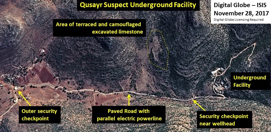
Figure 1. A November 28, 2017 DigitalGlobe image provides an overview of the Qusayr facility.
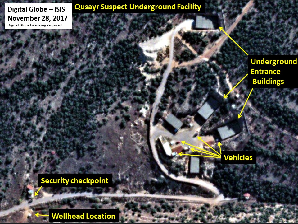
Figure 2. A November 28, 2017 DigitalGlobe image provides an overview of the central area of
the Qusayr site.
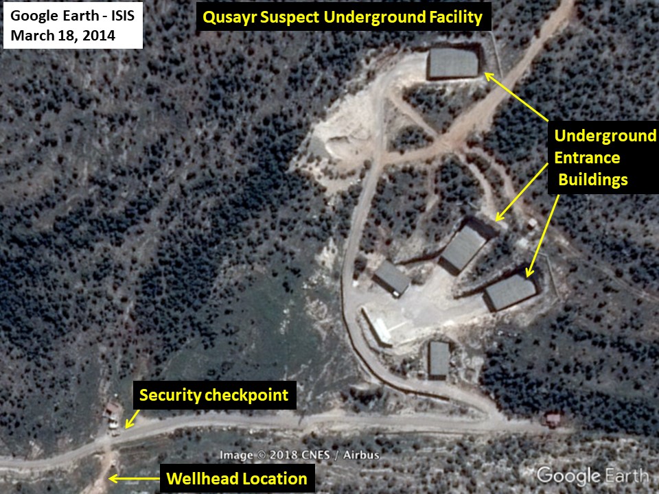
Figure 3. A March 18, 2014 Google Earth image provides an overview of what the central area
looked like four years ago.
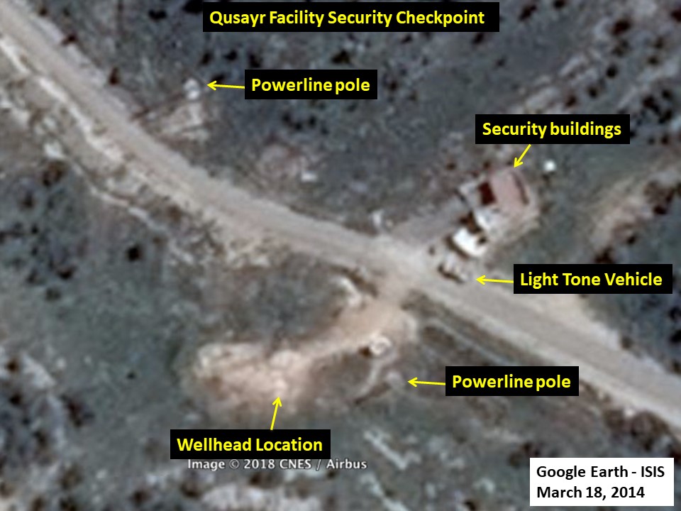
Figure 4. A March 18, 2014 Google Earth image shows the facility’s security checkpoint and
two power poles providing a line connection to the Syrian power grid.
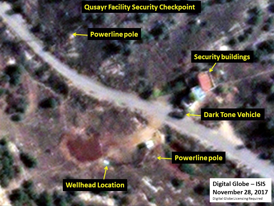
Figure 5. The facility’s security checkpoint, wellhead location, and the connection to a power
grid in November 2017.
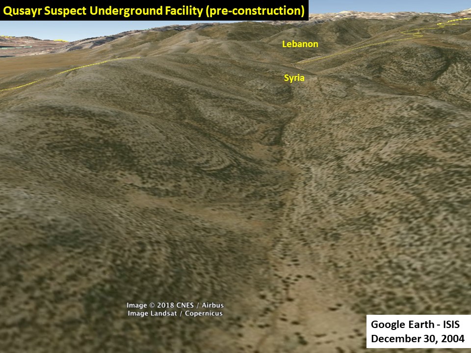
Figure 6. Qusayr is located in western Syria, very near to the Lebanon border.
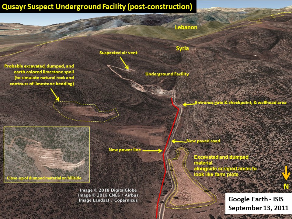
Figure 7. An overview of the Qusayr facility in 3D perspective created using Google Earth.
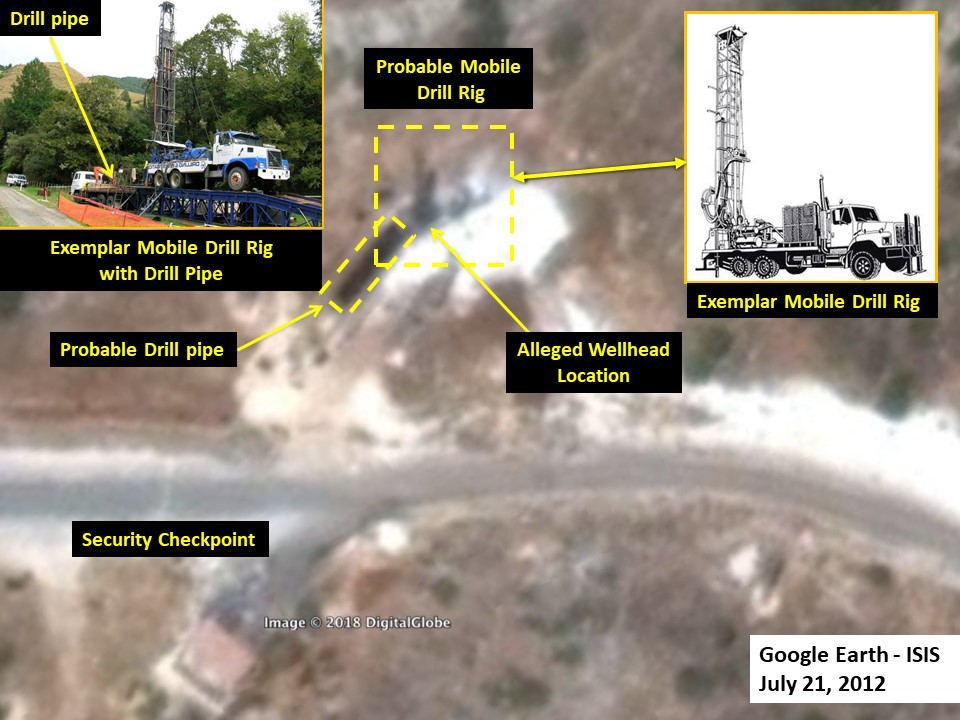
Figure 8. The shape of a potential mobile drill rig is visible at the alleged wellhead location, in
accord with the Der Spiegel report.
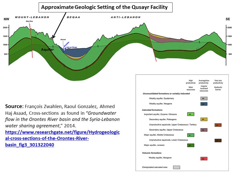
Figure 9. This cross-section diagram shows that Qusayr lies within a region having a “major”
aquifer in limestone dating to the Middle Cretaceous period. The west-east cross-section is one
of four in the report, but it is the one that is the closest to the Qusayr facility, and is also the
most representative of the geology and hydrology of the Qusayr facility. The report states:
This hydrogeological cross-section is located in the upstream part of the Orontes River, where it flows in the Beqaa valley between the Mount Lebanon and the Anti-Lebanon Mountains. The system of Yammmouneh fault is visible in the Mount Lebanon, where it probably forms a preferential flow path for recharging the major Cretaceous and Jurassic aquifers. The Ain ez Zarqa spring, which spurts out in the bed of the Orontes Rivers, is present on this cross-section. This resurgence ensues from probable fractures allowing the flow of water from the middle Cretaceous through the Neogene formation. The middle-Cretaceous is saturated under the Beqaa; the groundwater level is located at the edge of the Neogene era. Overflow springs can occur when the groundwater level rises above the edges of the plain. The recharge of the middle-Cretaceous and Jurassic aquifers comes mainly from the Anti-Lebanon Mountains. Most of the precipitation falling on the Mount Lebanon flow towards the Mediterranean.
1. Erich Follath, “Assad’s Secret: Evidence Points to Syrian Push for Nuclear Weapons,” Der Spiegel, January 9, 2015, http://www.spiegel.de/international/world/evidence-points-to-syria-still-working-on-a-nuclear-weapon-a-1012209.html↩
2. Stephen Farell, “Israel admits bombing suspected Syrian nuclear reactor in 2007, warns Iran,” Reuters. March 20, 2018, https://www.reuters.com/article/us-israel-syria-nuclear/israel-admits-bombing-suspected-syrian-nuclear-reactor-in-2007-warns-iran-idUSKBN1GX09K; Judah Ari Gross, “Ending a decade of silence, Israel confirms it blew up Assad’s nuclear reactor,” The Times of Israel, March 21, 2018, https://www.timesofisrael.com/ending-a-decade-of-silence-israel-reveals-it-blew-up-assads-nuclear-reactor/ ↩
3. Michael Schwirtz, “U.N. Links North Korea to Syria’s Chemical Weapons Program,” The New York Times, February 27, 2018, https://www.nytimes.com/2018/02/27/world/asia/north-korea-syria-chemical-weapons-sanctions.html ↩
4. Jennifer Griffin and Lucas Tomlinson, “New Satellite Photos Show Iran Establishing Another Base in Syria,” Fox News, February 27, 2018, https://www.reuters.com/article/us-israel-syria-nuclear/israel-admits-bombing-suspected-syrian-nuclear-reactor-in-2007-warns-iran-idUSKBN1GX09K; Judah Ari Gross, “Ending a decade of silence, Israel confirms it blew up Assad’s nuclear reactor,” The Times of Israel, March 21, 2018, https://www.timesofisrael.com/ending-a-decade-of-silence-israel-reveals-it-blew-up-assads-nuclear-reactor/ ↩
5. David Albright and Paul Brannan, “The Al Kibar Reactor: Extraordinary Camouflage, Troubling Implications,” Institute for Science and International Security, May 12, 2008, http://isis-online.org/uploads/isis-reports/documents/SyriaReactorReport_12May2008.pdf ↩
6. Erich Follath and Holger Stark, “The Story of ‘Operation Orchard’ - How Israel Destroyed Syria’s Al Kibar Nuclear Reactor,” Der Spiegel, November 2, 2009http://www.spiegel.de/international/world/the-story-of-operation-orchard-how-israel-destroyed-syria-s-al-kibar-nuclear-reactor-a-658663.html ↩
7. David Albright and Robert Avagyan, “Syria’s Past, Secret Nuclear Program Poses Proliferation Risks,” Institute for Science and International Security, September 12, 2013, http://isis-online.org/uploads/isis-reports/documents/Marj_as_Sultan_12sept2013.pdf ↩
8. Erich Follath, “Assad’s Secret: Evidence Points to Syrian Push for Nuclear Weapons,” Der Spiegel, January 9, 2015, http://www.spiegel.de/international/world/evidence-points-to-syria-still-working-on-a-nuclear-weapon-a-1012209.html ↩
9. “According to intelligence agency analysis, construction of the facility began back in 2009. The work, their findings suggest, was disguised from the very beginning, with excavated sand being disposed of at various sites, apparently to make it more difficult for observers from above to tell how deeply they were digging,” Der Spiegel (2015), op. Cit. ↩
10. Myriam Saadé-Sbeih, François Zwahlen, Ahmed Haj Asaad, Raoul Gonzalez, Ronald Jaubert, “Groundwater flow in the Orontes River basin and the Syria–Lebanon water sharing agreement,” DIKTAS, Karst Without Boundaries Conference, June 11-15 2014, Dubrovnik, Croatia, https://www.researchgate.net/publication/301322040_Groundwater_flow_in_the_Orontes_River_basin_and_the_Syria-Lebanon_water_sharing_agreement ↩
11. U.S. Army Engineer Reactors Group, Engineering Division, “Environmental Radiation Monitoring Plan for SM-1A Nuclear Power Plant Fort Greely, Alaska,” Fort Belvoir, VA, May 1971, http://www.dtic.mil/dtic/tr/fulltext/u2/726323.pdf ↩
12. “Exclusive: North Korea runs underground military base near Assad’s hometown,” Zaman Al Wasl, March 6, 2018. https://en.zamanalwsl.net/news/article/33363/ ↩
 email us
 twitter